
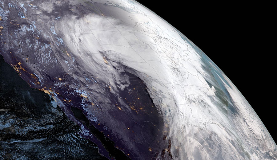
NOAA’s GOES West satellite captured this GeoColor limb view of the powerful winter storm system on Wednesday, March 13, 2019, before sweeping eastward across much of the Central U.S. Image: NOAA
It’s been a strange few months in the weather department. Last week, the middle of the country was smashed by an angry Mother Nature—howling wind, torrential rains, and weird amounts of snow forced many communities into a standstill. Nearly 1,500 flights within, into or out of the United States were canceled, according to FlightAware.com, and now Midwest rivers are bloated and bursting their banks, flooding vast areas and forcing hundreds to evacuate, and at least two people are dead.
You know what caused it all? A bomb cyclone.
When the barometric pressure plummets quickly (technically 24 millibars or more in 24 hours), shit gets weird up in the atmosphere, and it gets weird quick. When a storm system makes its way over the relatively warm water in the western Atlantic and cold air from the Arctic sweeps in behind, the difference in the two air masses bolsters the storm system. The colder the air and the warmer the water, the more violent the storm becomes. The lower the pressure inside the storm, the stronger the winds are around it. As it moves, it sucks up as much moisture as it can, then dumps it all over the place.
While seeing what happens during a bomb cyclone generally means standing outside in terrible weather, thanks to modern science, we can also see what one looks like from the top down—and it looks incredible.
Before this morning’s sunrise, #GOESWest captured this GeoColor limb view of the powerful winter storm system that’s causing “extremely dangerous” travel conditions across the Central U.S. Learn more: https://t.co/SSx4Pd6XL6 pic.twitter.com/eEux2TYA2Y
— NOAA Satellites (@NOAASatellites) March 13, 2019
#GOESEast got a closer look at the #bombogenesis developing over the Central U.S. during this morning’s sunrise. A bombogenesis occurs when a mid-latitude cyclone rapidly (or explosively) intensifies over a 24-hour period. Find out more: https://t.co/svMy2rP6aq pic.twitter.com/pjO6TvnAJo
— NOAA Satellites (@NOAASatellites) March 13, 2019
