
Photo: NOAA
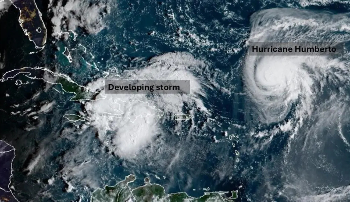
The Fujiwhara Effect is most commonly seen in the Western Pacific, but this week, forecasters are monitoring two storms in the Atlantic that may result in the rare phenomenon. The first storm is Humberto, which was elevated to the third hurricane of the 2025 Atlantic season early Friday morning. Forecasters expect it could be elevated to a Category 4 before it dies. The second storm is designated as Invest 94L, a system that’s expected to develop into Tropical Storm Imelda.
Both storms are currently over the Atlantic Ocean and their individual paths are forecast to steer clear of U.S. shores, technically. But what has forecaster’s attention with both is their potential proximity to one another as Humberto strengthens through the weekend and “future” Imelda develops and strengthens. As of Friday morning, Humberto was about 450-465 miles northeast of the northern Leeward Islands in the central Atlantic Ocean. Meanwhile, Invest 94L is located west of Humberto, somewhere near the Dominican Republic and Haiti. Future storm Imelda is expected to have impacts to parts of the Southeast U.S. on its own, but its proximity to Humberto could trigger the Fujiwhara Effect, and that could throw any and all current predictions out the window.
What Is the Fujiwhara Effect?
The Fujiwhara Effect takes place when two major storms interact with each other. Meteorologists often explain the phenomenon as two storms dancing around one another, triggered by their proximity forcing them closer and closer together until their centers eventually rotate like the last two players in a game of musical chairs. Tropical systems like Humberto and future storm Imelda are expected to be large enough that this could happen, even if the storms as far as 900 miles from one another.
What happens next varies by size and strength of each storm.
“If one hurricane is a lot stronger than the other, the smaller one will orbit it and eventually come crashing into its vortex to be absorbed,” explains the National Weather Service. “Two storms closer in strength can gravitate towards each other until they reach a common point and merge, or merely spin each other around for a while before shooting off on their own paths. In rare occasions, the effect is additive when the hurricanes come together, resulting in one larger storm instead of two smaller ones.”
What to Expect from Humberto and Future Imelda?
Forecasters are currently monitoring three main scenarios that have emerged in computer models, according to the BBC:
-First, the developing, deepening low could become very slow-moving, affecting the western Bahamas for a number of days before moving out to sea.
-Second, it could make landfall around Georgia and South Carolina in the U.S., bringing flooding rain and damaging winds.
-Finally, an area of high pressure could block the low from reaching the U.S. East Coast, and instead it just stays out to sea.
