
Photo: NOAA
The World Meteorological Organization (WMO) declared last week that this winter’s “weak” La Niña is officially fading away. What happens after that? Forecasters are expecting a brief ENSO-neutral period (neither El Niño or La Niña conditions present) and then calling for a strong El Niño to roll in later this year. Initially, that chatter included the potential El Niño being a “Super El Niño,” but now there are mumbles of something even grander: a “Godzilla El Niño.”
“The WMO community will be carefully monitoring conditions in the coming months to inform decision-making. The most recent El Niño, in 2023-24, was one of the five strongest on record and it played a role in the record global temperatures we saw in 2024,” said WMO Secretary-General Celeste Saulo.
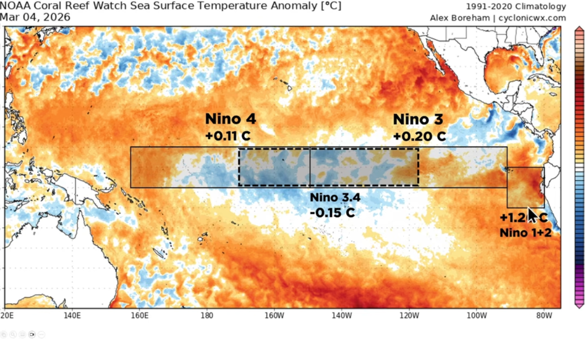
The recent weak La Niña event is expected to fade into ENSO (El Niño-Southern Oscillation) -neutral conditions which may swing to a warming El Niño episode later this year, according to the latest WMO El Niño/La Niña Update.
Check out the full update 👉 https://t.co/BIPsbctstt pic.twitter.com/YuJ98I7xnZ— World Meteorological Organization (@WMO) March 3, 2026
What Is A Godzilla El Niño?
The term Godzilla El Niño popped up a little over a decade ago as conditions for a massive El Niño were brewing over the Pacific. A NASA scientist by the name of Bill Patzert coined the phrase as a way of illustrating the expected scale of weather impacts, and that drew comparisons to the historic El Niño of 1997-1998. In the simplest terms, he was setting the table for a winter that would bring “once-in-a-generation storms to the West.” San Francisco received the most rainfall it had seen in 100 years that winter (1997-1998). Los Angeles received a year’s worth of rain in just one month. And snowfall in many parts of the West reached double the average.
What About Waves?
Predicting an all-time winter just as you’re sliding into spring — a full two season ahead — is a fool’s errand. There are no guarantees, but most surfers with a few notches on his or her belt know that comparisons to the winters of 1997-1998 and 2015-2016 typically mean a lot of waves on the way for California and Hawaii.
As Surfline’s Kevin Wallis reminded us just a couple years ago though, no two El Niños are the same. “And we don’t necessarily see significant impacts with every El Niño. But where we do tend to see the most significant impacts is when we’ve got strong or very strong El Niños, which is what we’re in this year,” he explained back in 2023. “One of the strongest signals we see for enhanced surf is in the North Pacific – California or Southern California, especially. In northern California, a lot of times it gets stormy. And in Hawaii, we will tend to see enhanced surf, but if you move away from that, there’s a lot more places scattered throughout the eastern end of the Pacific basin that are either west or northwest facing and would benefit from the same swells that California and Hawaii would.”
The National Oceanic and Atmospheric Administration (NOAA) isn’t being so bullish. At least not yet. In a March 9 update, the administration mostly focused on our current transition out of this winter’s La Niña. They see a transition to ENSO-neutral that persists through May-June 2026.
“For the late summer and beyond, there is a 50-60 percent chance of El Niño forming, though model uncertainty remains considerable and forecasts made this time of year tend to have lower accuracy,” NOAA admitted.
In other words, we’ll all have to keep a watchful eye on these bold predictions for a “Godzilla El Niño.”
