
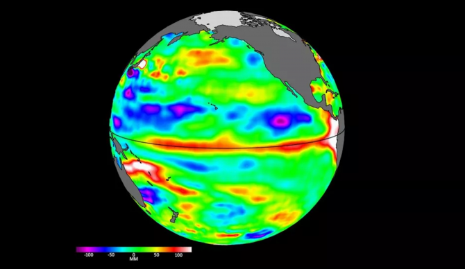
This image shows the emergence of waves, called Kelvin waves, moving warm water across the equatorial Pacific Ocean from west to east during March and April. The signals can be an early sign of a developing El Niño, and were detected by the Sentinel-6 Michael Freilich sea level satellite. Credit: NASA//JPL-Caltech
There are multiple organizations around the world watching the Pacific Ocean like a hawk right now, including people whose tools operate outside of this world. Just last week, NOAA released a monthly update on trending weather data and its relevance to the potential for an El Niñ0 this year. The current prediction to this point is that an El Niño is mostly likely a lock and there is a strong chance it will be a big one that lasts through the year. Now we have NASA weighing in with their own observations of “2-4 inch” waves forming around the equator. And they can see them from space.
In a statement released May 12, NASA explained that the U.S.-European satellite Sentinel-6 Michael Freilich uses a radar altimeter to monitor the movement of ocean water through microwave signals that measure the height of the ocean surface. When the altimeter passes over areas that are warmer than others, that area will show higher sea levels, and they found just that near in the equatorial Pacific from the beginning of March through end of April. The sea level rise can be as small as just a few inches high but miles wide, something they identify as Kelvin waves. But those waves are a significant predictor in the early formation of an El Niño event because, as NASA explains in its statement, “water expands as it warms.” And they say all those miniature waves were moving from west to east along the equator, aimed at the west coast of South America.
“The Sentinel-6 Michael Freilich satellite data shown here covers the period between the beginning of March and the end of April 2023,” NASA explained in a statement. “By April 24, Kelvin waves had piled up warmer water and higher sea levels (shown in red and white) off the coasts of Peru, Ecuador, and Colombia. Satellites like Sentinel-6 Michael Freilich can detect Kelvin waves with a radar altimeter, which uses microwave signals to measure the height of the ocean’s surface. When an altimeter passes over areas that are warmer than others, the data will show higher sea levels.”
So far, experts have indicated El Niño is likely and just about every new update suggests we’re due for one. But it will take a few more key ingredients (and time) before anybody officially declares it. Of courses, with or without the stamp of certainty from an organization like NOAA, we’ll see and feel the effects in the coming months.
“If it’s a big one, the globe will see record warming, but here in the Southwest U.S. we could be looking at another wet winter, right on the heels of the soaking we got last winter,” said Josh Willis, Sentinel-6 Michael Freilich project scientist at NASA’s Jet Propulsion Laboratory in Southern California.
