
Winter. It’s on. Graphic: The Weather Channel
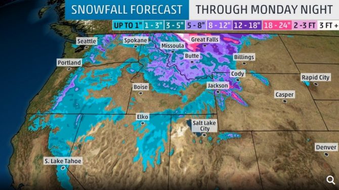
Whether they’re ready for it or not, the weather’s about to get real in mountain towns of the Northern Rockies that include ski resorts in Idaho, Montana and parts of Wyoming. Forecasters are calling it “historic,” in fact, predicting that areas in the region could receive up to a foot of snow by the end of the weekend with some areas even getting multiple feet.
https://www.instagram.com/p/B2xDbw5AoEH/
According to The Weather Channel, the “historic” hype comes out of central Montana where snow accumulations could set records for this time of year. “This early-season winter storm and/or blizzard has the potential to set a new benchmark for snow accumulations, cold temperatures and resulting impacts for parts of the northern Rockies and the Rocky Mountain Front,” NWS-Great Falls wrote.
Our best analog event for this weekend’s storm compares well to Sept 22-24,1934. Some locations could be near or below daily record low temperatures, with possible new September records for 2- or 3-day snow totals. So, the comparison is with respect to September events.
— NWS Great Falls (@NWSGreatFalls) September 25, 2019
It’ll also be a windy one, says the National Weather Service, which issued a winter storm warning starting Friday night for northern and western Montana, northern and central Idaho, and northern Washington. Gusts of 40-50 mph are expected with speeds up to 60 mph in some areas especially in that northwestern Montana (Whitefish) zone.
https://www.instagram.com/p/B2w4xXZA-a4/
As far as resorts go, Mt. Baker, Stevens Pass, Washington, Schweitzer, in Sandpoint, Idaho, Whitefish, Montana as well as Big Sky and Bozeman (possibly), and Jackson Hole, Wyoming will all see the effects of this storm as well as the high mountain regions in the same general vicinity (obviously). Lifts aren’t scheduled to start spinning for more than a month at many resorts but it looks as though they’ll be some boot packin’ and skinnin’ for turns in some areas of the West after the weekend if it doesn’t all melt away with a warming trend. Thus is fall.
https://www.instagram.com/p/B27ZLVvHShw/
