
Map generated by the Natural Resources Conservation Service
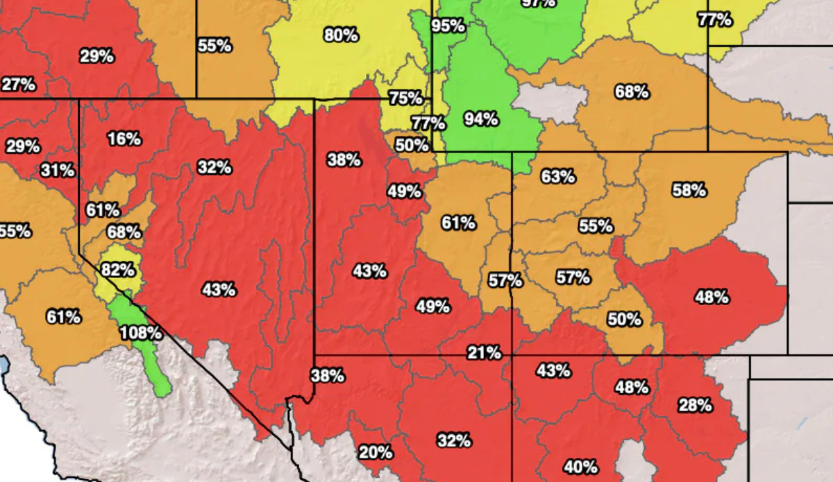
A report issued by the U.S. Department of Agriculture’s National Resources Conservation Service has declared Utah’s snowpack for this winter now sit at record lows. The January 31 measurements reported an average snow-water equivalent of 5.1 inches, squeaking under the previous record low of 5.2 inches since the Natural Resources Conservation Service began collecting data with the SNOTEL measuring equipment in 1980.
The report outlined that the data doesn’t just come from a few key locations. There are 140 SNOTEL sites across the state that report real-time data of snow depth. To be exact, 31 of those sites were reporting the worst snow-water equivalent ever for January 31, with another 12 stations reporting the second worst. That amounts to the entire state having just around one-third of its normal snowpack going into February.
RECORD LOW SNOWPACK: 67 of 139 snowpack measuring sites in Utah are now experiencing their all-time lowest levels to date (OCT 1 – FEB 1) since records began in 1981. When averaging out the numbers statewide, this the worst we’ve seen it at this time in the season – 57% of normal pic.twitter.com/KQndsg8o8v
— Matthew Johnson (@KSL_Matt) February 2, 2026
The data mostly serves to inform decisions on water conservation and management, but it has an obvious immediate impact on outdoor lovers in the area who ski and snowboard. Later opening dates and fewer open ski trails have been the norm across much of the West, and Utah’s situation is no different. Social media is packed with snarky videos showcasing the bleak conditions and remarks about having paid for non-refundable ski trips. Ironically, there was no shortage of predictions last fall that this winter could be a dry one.
View this post on Instagram
There isn’t much hope from forecasters that the season will be saved, although it’s possible. At least further out West and into the Pacific Northwest forecasts are showing a “crack in the lid” next week.
“The Cascade Range looks best positioned for the first meaningful reload, with lighter spillover into the Northern Rockies and some moisture possibly sagging into far northern California late in the weekend,” Powderchasers wrote Tuesday. “Temperatures still lean above normal across much of the West in this window, so snow levels and the timing of colder air will decide whether this refresh feels like midwinter or late March…”
