
Photo: LOLA
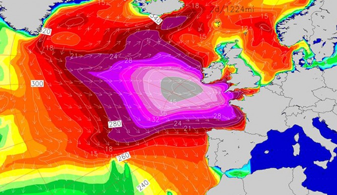
The XXL world has spent most of its northern hemi winter in the Pacific. With El Niño creating chaos in that area of the world the North Atlantic has lit up big wave spots like Nazaré and Punta Galea at a much more modest rate. If LOLA’s newest purple blob is any indicator though, Western Europe could be looking at a run of XXL swell in the very near future.
A low moving off the coast of Greenland has been pumping out “satellite measured seas in excess of 40-45 ft” according to a Surfline report. Meanwhile, more lows – particularly one moving from the US side of the Atlantic – are moving east as well, setting up a swell that will rear its head on Europe’s Western shores through the weekend and peaking on Monday. Aimed at the Bay of Biscay, this new swell is forecast to produce waves larger than 20 feet with a similar path as the Hercules swell of early 2014. Of course, while some forecasters have pointed out the similarities to that historic swell it’s not to predict that the current system will cough up the same size and conditions. In fact, stormy conditions are expected in much of the northeast Atlantic, potentially throwing a wrench in this swell maximizing its potential. The XXL surf is expected to peak early in the week for the Isles and peaking for mainland Europe Tuesday while making its way south.
Periods, conditions and comparisons to Hercules aside, just looking at the swell models from this month next to a shot of January 2014’s system tells much of the story on its own. Europe is in for some XXL surf but at first glance it doesn’t look like the meanest swell the North Atlantic has churned up for them.
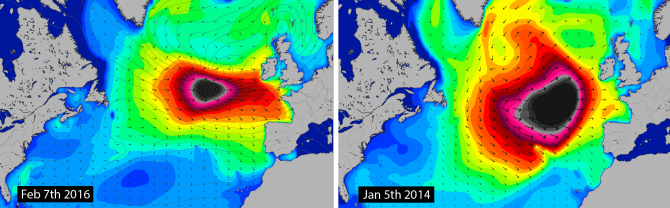
A side by side comparison of 2014’s Hercules to this year’s “mini Herc” shows similar track but a vast difference in the systems’ reach.
