
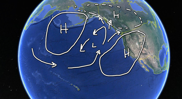
One of the things that stood out for me this fall was the presence of a strong high over the Bering Sea that would occasionally slip down over the Aleutians and significantly stunt the flow of storms that generally track out of the West Pacific heading our way. There were even times, right at the beginning of November, where it linked up with the lower mid-latitude ridge and formed a super high pressure with a nearly 1048-1050mb core along the ocean surface. Just for reference, anything over 1013mb is considered high pressure so a 1050mb high is like building a steel reinforced mountain of air, and this one sat across all of the important parts of our swell window.
In fact, the storm that just blasted Hawaii with north swell was a byproduct and testament to the strength of those high pressure ridges. They were so dense that they were able to encapsulate a storm and actually reroute it southward toward the islands rather than let it follow the more natural path eastward like a storm in those latitudes usually does.
Missing Piece #2: East Pacific Tropics
This fall was a particularly bad season for the East Pacific Tropics.
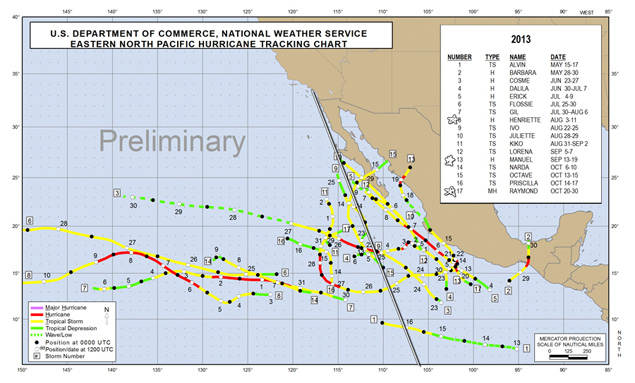
While we had a few storms cruising through the EPAC, most of them either headed out to Hawaii or stayed in the shadow of Baja. The few that had enough steam to push WNW out past the Pacific Side of Baja ended up hitting cold water and weakening when they made a move toward our swell window.
August, September and October are generally when tropical storms make a more concentrated effort to move out of the warm waters where they develop, but most importantly, this is the time of year when they usually curve back toward our region. This year, they either hooked too early and ended up impacting land or they never made the turn and headed out to the west, toward Hawaii, so fast that they were out of swell-making range before they had any time to set up fetch.
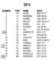 The season was pretty sparse in terms of the number of storms. Sure we had 17 named systems, but starting in August, we only had three that actually reached Hurricane strength and only two of those tracked far enough west to even get in our swell window.
When you get down to it: Fall needs combo swell
Looking back at this fall, you can see that getting good waves during August, September and October (and early November) is more of a group effort than any other time of the year. We need to have active storms in the North Pacific, the EPAC tropics, along with at least some remaining (or better) storm activity in the South Pacific. In fact, we need even more out of the NPAC and EPAC to make up for the weakening/zonal shift that the SPAC starts to make as it transitions out of its winter season.
So was this the worst fall of all time?
Nope. Not by a long shot. I know it is hard to keep in perspective when you are riding yet another small mushburger for what seems like the last couple of months. And, of course, having access to an insane amount of surf photos and footage from all over the world only seems to make it worse because you see how good it is somewhere else (and it is always good somewhere out there), which makes our small surf that much more apparent.
Don’t get me wrong. This fall wasn’t perfect. Most of our swells were small and you probably found yourself riding your small wave gear more than you would have liked. However, we did get a few overhead days with great conditions along with plenty of rideable days with good weather, which if you look back through the years, is pretty typical for the fall season. It is easy for us surfers to have pretty selective memories. The average/below-average fall seasons aren’t the ones we remember. It is the insanely good ones that are seared into our saltwater-soaked brains.
