
An El Niño weather pattern is likely in the coming months, according to two major weather prediction services. Photo: NOAA
It’s looking increasingly likely that El Niño is going to form in the eastern Pacific Ocean in a few months. According to NOAA’s Climate Prediction Service (CPS) and the Australian Bureau of Meteorology, there’s up to a 60 percent chance of El Niño’s formation this summer.
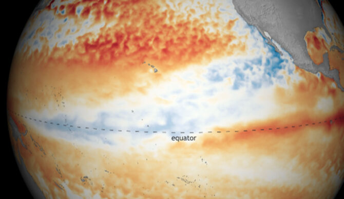
“The equatorial subsurface temperature index (average from 180°-100°W) significantly increased, reflecting the strengthening and expansion of above-average subsurface temperatures across the Pacific Ocean,” CPS explained. “Atmospheric anomalies weakened due to subseasonal variability, but still reflected aspects of La Niña.”
El Niño years are a blessing and a curse. In general, the weather pattern raises average global temperatures, which in turn gives more energy to storms. That means more extreme weather, which can be good if you’re a person who likes lots of snow and big waves. But it can also have severe consequences. Especially as our planet is barreling towards something frightening.
“El Niño isn’t all bad; some of the changes it causes in atmospheric circulation can reduce the chances of severe hurricanes in the North Atlantic,” NOAA wrote. “But many other changes are highly destructive and dangerous, so advance warning of El Niño’s approach is extremely important for emergency preparation. NOAA satellites are constantly collecting information on sea surface temperatures around the globe. NOAA also operates a network of buoys that measure temperature, currents, and winds in the tropical Pacific Ocean. Every day, these buoys transmit data that are immediately available to researchers and forecasters around the world.”
Although 2025 ended with a La Niña pattern (which can be relied on to lower global temperatures), it was still one of the hottest years on record. If the upcoming months do see an El Niño pattern emerge, 2026 and 2027 will likely be hotter than 2025.
It is, however, difficult even for the best prediction agencies to predict what’s to come this far in advance. El Niño, for those unaware, is also called the El Niño–Southern Oscillation (ENSO). In short, it’s a climate cycle that occurs every few years, according to the fluctuations in ocean temperatures and atmospheric pressure in the tropical Pacific. It’s responsible for weather around the world, from heatwaves to rainfall and droughts to cylcones. The stronger the El Niño, the more powerful those things can become.
El Niño, as we’ve established, is the heating phase. La Niña cools things down, and in between the two there exists a neutral pattern. If the predictions come to fruition, we can expect more rain and more floods in the southern U.S. and southern Europe, but the northern U.S. and Canada will be drier and warmer than normal.
“The pattern shifts back and forth irregularly every two to seven years, bringing predictable changes in ocean temperature and disrupting the normal wind and rainfall patterns across the tropics,” NOAA said. “These changes in the seasonal climate of the world’s biggest ocean have a cascade of global side effects.”
