
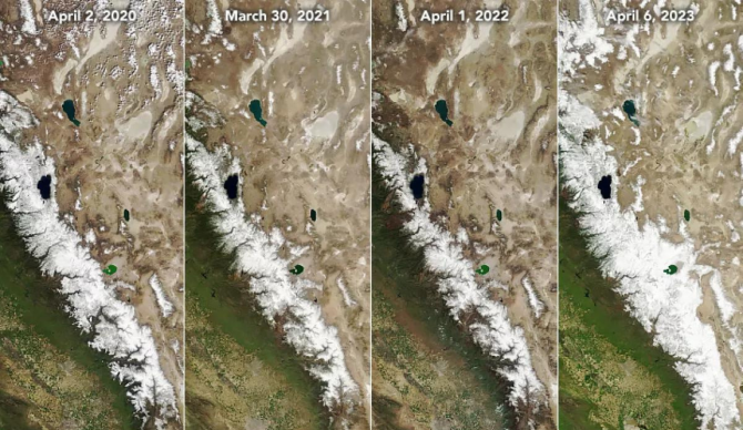
Photo: NASA
Plenty has been said about the historic snowpack throughout the Sierras this winter, with atmospheric river after atmospheric river plowing through the region for months on end. But words can’t exactly paint the same picture as, well, an actual picture.
In recent years, the West Coast saw a trend of early winter storms and drier months between January and April. That led to the dwindling snowpack levels we would see by April 1 of each year and the resulting never-ending drought. This year was different, with a flurry of storms bringing colder weather and dumping massive amounts of snow over short periods late in the season. Parts of the Sierra Range even saw snowfall in the first week of May, leaving little to no room for that significant snowpack to start melting quite yet. And experts are expecting quite an impact when all the snow does start to melt.
Back to the pictures. NASA released images this week from its Terra satellite showing just how different it all looks now that the record winter is over. The 2020 through 2022 winters were some of the driest the region has ever seen, with April of 2022 leaving the Sierras looking barren in NASA’s images. Snowpack was at 50 percent of average levels in April 2020. The next year, that number was 62 percent. By April 2022, the snowpack was back down to just 35 percent. It all skyrocketed this year, where California’s statewide snowpack sat at 243 percent to start May. The before and after images from April 2022 to April 2023 show the drastic change most clearly.
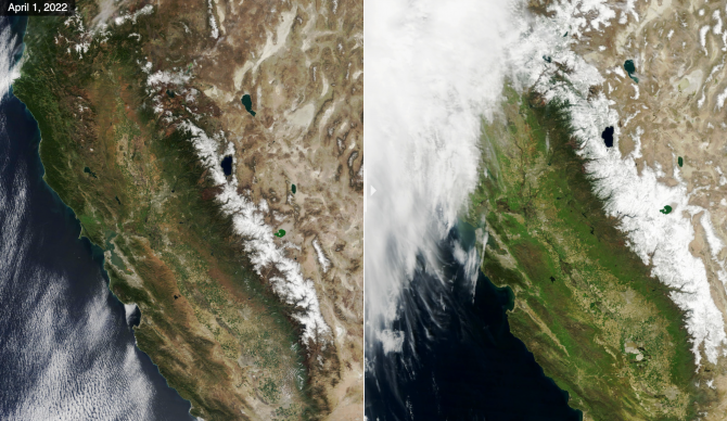
Before and after. April 1, 2022 vs April 6, 2023. Photo: NASA
