
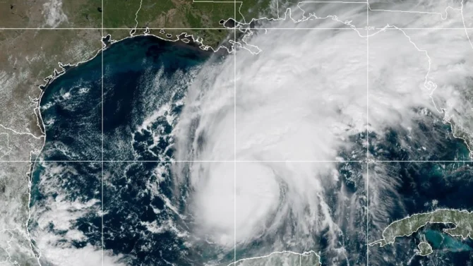
The Atlantic’s first hurricane will make landfall with devastating force. Photo: NOAA

After a summer and fall of doldrums, Gulf Coast surfers finally have a storm to chase. Hurricane Isaias formed in the Gulf of Mexico, becoming the season’s first Atlantic hurricane — which El Niño conditions have stymied.
Isaias is a Category 1 hurricane with 85 mph sustained winds and is currently 380 miles south of the Mississippi River mouth. The National Hurricane Center says conditions are ripe for strengthening as it moves north. Winds could speed up to 110 mph, nearing Category 3 status.
The weather models agree the storm will still have hurricane-force winds when it makes landfall in Alabama or the Florida Panhandle late Friday night or early Saturday morning. Coastal communities are preparing for storm surge that could reach as high as seven feet in some areas, and torrential rainfall.
The National Hurricane Center warns that the central Gulf Coast should prepare for three to seven inches of rain, but localized totals could reach as high as 15 inches. Additionally, there is a chance of tornadoes Friday night through Saturday.
“The combination of a dangerous storm surge and the tide will cause normally dry areas near the coast to be flooded by rising waters moving inland from the shoreline,” the center’s warning reads. “Flash and urban flooding is possible across the region, with considerable impacts possible across much of southern Alabama and the Florida Panhandle into southwestern Georgia. River flooding is also expected, some of which could be significant.”
10 AM CDT Thu Oct 8 (Advisory 8) Key Messages for Hurricane #Isaias. Latest info: https://t.co/GrztW6mQJV
10 AM CDT jueves 8 de octubre (Aviso 8) Mensajes clave sobre el huracán #Isaias. Más información: https://t.co/GrztW6mQJV https://t.co/pt7rOvQWeV
— National Hurricane Center (@NHC_Atlantic) October 8, 2026
As those living in Florida’s panhandle brace for impact, surfers on Florida’s west coast are keeping an eye on Isaias for a run of swell.
“Isaias is expected to strengthen while moving toward the east-northeast, which is a favorable scenario,” Surfline says. “We have seen forecasted surf heights trend up, and it looks like some fun surf in the cards off southwest swell. (Saturday) is a day to watch and would start making some plans to grab a few waves.”
Any swell that hits will be short-lived, as forecasts predict swell will trend down throughout the day on Sunday.
Isaias marks the end of a historic drought of hurricanes in the Atlantic. This year was the first season since 1914 that the Atlantic had not produced a hurricane by September 21. Only in 1914 and 1907 did the Atlantic see no hurricanes in recorded history.
Isaias is not just the season’s first hurricane, but the first to make landfall in the U.S. since hurricane Milton came ashore in Western Florida in 2024.
While the Atlantic Hurricane season has been sleepy, the Pacific has kicked into overdrive thanks to an historic El Niño. The Pacific has seen multiple Category 5 storms and, on several occasions, three hurricanes spinning at once between Hawaii and Mexico. Tropical Storm Simon is expected to become a hurricane tonight and make landfall on Central Mexico’s Pacific Coast on Sunday morning.

