
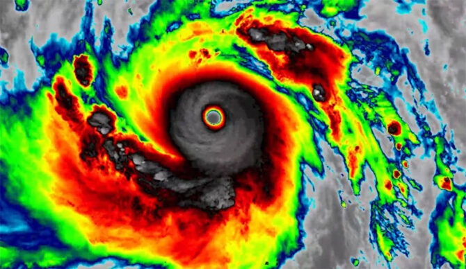
Super Typhoon Sinlaku is a BIG one. Image: CSU/CIRA & JMA/JAXA
Super Typhoon Sinlaku lays claim to something pretty big: the most powerful storm on the planet in 2026 — so far. And in the coming days, it’s expected to make its way over the Northern Mariana Islands, a U.S. territory. It’s a beautiful place made up of 14 islands that draw thousands of tourists every year. Some 45,000 people call the islands home.
The storm wasn’t much of anything until April 9. Until then, it was simply a smaller cluster of weak storms. When they joined forces over the Western Pacific, however, all the energy linked arms and became something monstrous.
As of the morning of April 13, Super Typhoon Sinlaku is flying across the ocean with wind gusts hitting 190 miles per hour. As it nears shore, thankfully, those gusts are forecasted to diminish, but the Northern Mariana Islands are still likely in for a rough time. Nearby Guam doesn’t seem to be in the storm’s path, but residents are still being warned to batten down the hatches.
“Sinlaku is expected to gradually weaken the next few days, but is still expected to cross the Marianas as a category 4 or 5 typhoon,” the U.S. National Weather Service (NWS) said in a statement on Monday.“For those under a warning in the Marianas, the window of time to complete preparations for the protection of life and property is very soon to close. Evacuate if directed to do so by local officials, or if your home is vulnerable to high winds or flooding.”
Sinlaku is making its way through an area in the Western Pacific that’s called Typhoon Alley, for obvious reasons. “The region is an ideal setting for tropical cyclones, as it hosts the warmest open-ocean waters on Earth, providing the heat and moisture that fuel storm development,” IFL Science wrote. “The basin is also exceptionally wide, giving storms room to strengthen over thousands of miles of open water before making landfall on the ocean’s coastlines and scattering of islands.”
