
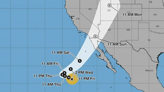
Southern Californians should be prepared for some adverse weather this weekend. Photo: National Hurricane Center

As Southern California enjoys south swell from Hurricane Rachel, the storm could have a lot more in store by this weekend. Rachel is expected to make a turn to the northeast and speed toward Northern Baja California and the Southern California coast.
While Rachel will weaken into a tropical storm in the next 24 hours, it could still make landfall as a post-tropical cyclone with winds as strong as 45 miles per hour. Rain is expected across Southern California as well, and wind could whip up storm surge that threatens to flood low-lying areas.
There is still uncertainty about where Rachel will hit. The National Hurricane Center’s model says it could hit anywhere between Orange County and Punta Colonet. Google’s Weather Lab predicts landfall somewhere south of Ensenada, Mexico.
“Potential outcomes still range from ‘dry’ to ‘rare October rain and windstorm’ for places like San Diego,” climate scientist Daniel Swain said. “Details TBD. But things have certainly shifted in the direction of more substantial impacts.”
“One thing to watch out for: some models are showing a fairly strong (non-tropical) low pressure system near or just west of San Diego on Sun/Mon,” he added. “In addition to locally heavy rainfall, this could generate strong onshore winds that could lead to more significant coastal flooding.”
Surf conditions in Southern California will depend on how the storm acts in the following days. As the tropical storm approaches the coast, a long-period, Southern Hemisphere swell will simultaneously hit California.
“Swells partly generated by Rachel will build along the coast of Southern California and northern Baja California through the weekend,” the National Hurricane Center said. “These swells are likely to cause life-threatening surf and rip current conditions.”
While it appears Rachel’s Sunday landfall will bring poor wind conditions, there could be some interesting combo swells on Saturday with overlapping long-period south swell, fading mid-period Rachel swell, and shorter-period storm surf.
Stay tuned to forecasts in the coming days as Rachel’s path and its effects become clearer.

