
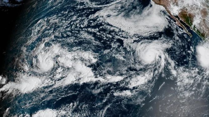
The Big Island is preparing for another close encounter with a hurricane. Photo: NOAA

While three hurricanes spinning between Hawaii and Mexico is usually remarkable, during the most extreme El Niño on record, it’s become rather pedestrian in 2026. As Hurricane Polo sets aim at Baja California, Tropical Storm Nolo is on a track that could cause widespread devastation in Hawaii.
Currently a tropical storm 455 miles south-southeast of Honolulu, Nolo is expected to become a hurricane tonight and a major hurricane within 72 hours. The storm could reach Category 3 status with wind speeds of 120 mph. While it’s not expected to make landfall on the Hawaiian islands, models predict a northward track that will bring it close to the Big Island before it makes a sharp turn to the west on Saturday night.
The National Hurricane Center warns that Nolo could bring ruinous rainfall to a landscape still recovering from Hurricane Lala’s destruction last month. Areas of the Big Island will see 15 to 20 inches of rain, with as many as 35 inches in extreme cases. Maui will be affected as well, with five to 10 inches of rain.
The center warned that rainfall could be “catastrophic” and flooding could be “life-threatening.”
“The time to finish preparations for significant heavy rain and flooding impacts on the Big Island is now as heavy rain increases in both coverage and intensity today and Friday,” the National Hurricane Center wrote. “Periods of heavy rain are expected to continue across the Big Island and Maui through the weekend.”
“Life-threatening, catastrophic flooding and mudslides are possible, especially in areas of steep terrain across the Big Island and Maui,” it added. “Across the remainder of Hawaii, lesser rainfall totals are expected, with isolated flooding possible.”
Earlier this month, Hurricane Lowell passed by the west side of Kauai, dumping 23 inches of rain on parts of the island.
Aside from the rain, the archipelago’s south coasts will see extreme swell and storm surge.
As water temperatures remain historically warm in the Eastern Pacific basin, the current trifecta of hurricanes is definitely not the season’s last hurrah. After Nolo, Polo, and Odalys run their courses, the National Hurricane Center is already predicting more storm formation within a week.

